
Hiking
Quimby Country sits squarely amidst the wildness and beauty of rugged New England. To the north lies Canada; to the east, the Connecticut River and New Hampshire; and to the west, lakes and peaks scattered amidst hundreds of thousands of acres of Vermont forest. All the following hikes are within a one-hour drive of Quimby’s.
Hiking at Quimby Country
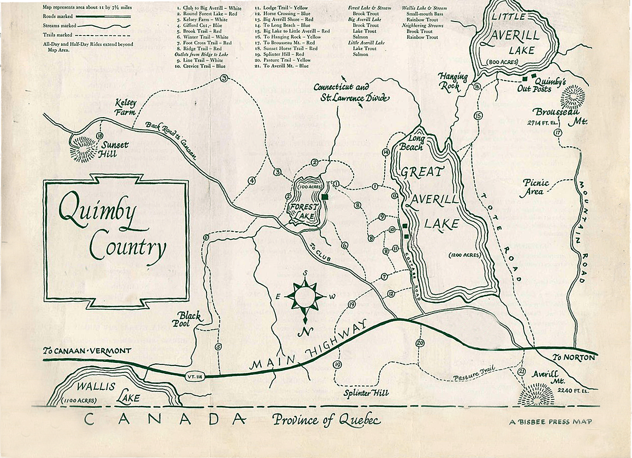
Quimby Country is crisscrossed by a network of trails as shown on this map. Just off the property, Averill Mountain, Brousseau Mountain, and Gore Mountain offer relatively easy climbs to spectacular views from their summit.
The trail marker for Averill Mountain is just a half mile west of the Lake View store on Route 114. The well-marked path up Mount Averill is just three-quarters of a mile and the 30-minute climb ends on a large rock overlooking Big Averill Lake. The mountain has a gradual ascent with vertical rise of 550 feet from the trail’s starting point. From the summit, you can see Table Rock in Dixville, NH, Mount Washington, and Jay Peak to the west.
The trail head for Brousseau Mountain is also on Rt. 114. One and a half miles west of the Lake View Store, turn left on Mountain Road and drive about 1.3 miles to a closed gate. From there, it’s about 45 minutes (1.6 miles) to the top on a well-marked trail. The climb up is gradual but rocky in some places. When you get to what seems like the summit, take another trail to the right to the lookout point, about two minutes away. This vantage point provides a wide panorama view of the White and Green Mountain ranges and the Silvio O. Conte National Fish and Wildlife Refuge.
To find the trail to the top of Gore Mountain, take Vermont Route 114 south from the Norton General Store for 9.9 miles. Pull off between Lake Station Road and Devost Road at the north end of Norton Pond. The trail enters through a small opening on the east side of the road. You’ll walk through a series of beaver meadows, cross several brooks and through the edge of a large area that’s been logged. From the summit, there are views of the Nulhegan Basin a popular bird and wildlife viewing area. The trail to the top is 3.8 miles, about 90 minutes to two hours.
Parc De La Gorge de Coaticook, Quebec
The best place to hike outside the Quimby Country area itself is actually in Canada. The Gorge Park of Coaticook is only about a 30 minute drive away and it offers 20 km (about 60 miles) of marked trails within three different areas. The most popular is the Gorge “Canyon” Trail, which includes the longest suspended footbridge in North America, which hangs over the 554-foot deep canyon. The Gorge is located on your right as you drive north out of the Coaticook city center on Route 147. When you leave the park, consider stopping at one of two places just a bit further up the road — Laiterie de Coaticook (Coaticook Creamery) turns milk from the surrounding farms into delicious ice cream; across the street, a new microbrewery (Microbrasserie, Coaticook), serves good food as well. Try the poutine, a French-Canadian favorite. Dogs are allowed inside the park, but must be kept on a leash at all times. Don’t forget your passport.
Mount Pinacle (Sentiers des Moulins), Baldwin, Quebec
Mount Pinacle (2,215 feet high) is just half an hour from Quimby Country in Baldwin, a small village in the Eastern Townships of Quebec. Park your car in the village lot in Baldwin, where you can then take a short walk to the Mount Pinacle trail which offers a spectacular view. Again, not for anyone afraid of heights, as Pinacle offers a stunning cliff wall.
In English, the title of this pleasant walk would be something like “Friends of St. Venant-de-Paquette’s Heritage.” Outside, it’s an easy and well tended trail that passes breathtaking scenery, stone sculptures, and placards with examples of local poetry. Inside, it’s an art galley and reception area. Public outdoor library. Audio guide available. Picnic tables. Children’s play area. Free ice cream after your visit. Dogs on a leash allowed. Restaurant and washroom with changing table onsite. Downloadable trail map. Open Monday through Saturday from mid-June to mid-September: 10 a.m. to 6 p.m. Entrance fee: Adult, $10. Student: (12-25 yrs old), $5. Family with children or students, maximum $20. Audioguide rental, $5. About 45 minutes from Quimby Country.
Mollie Beattie Bog Boardwalk, Brunswick, VT
This self-guided, 200-foot long boardwalk and trail offers exceptional viewing of wildlife, rare plants, and birds. Located on Rt. 105 in Brunswick, about an hour from Quimby Country. Nearby, at the end of Lewis Pond Road, is the Lewis Pond Overlook, another perfect place from which to observe wildlife. Visits can be combined with shopping in Island Pond and East Burke.
Monadnock Mountain, Lemington, VT
The 4.5-mile path up Monadnock Mountain starts in Lemington, Vermont, on Route 102 – River Road, just 0.2 miles north of the Bridge Street bridge from Colebrook, NH. Turn into the gravel pit from Route 102 and find a trailhead sign that indicates the beaten-down path through the meadow that eventually leads to a better-defined trail in the woods. The mountain is forested all the way to the summit, but you can climb partway up a fire tower for good views in all directions. This is a long round trip hike so plan accordingly.
Bluff Mountain, Island Pond, VT
The Trailhead and parking for this 3.2-mile round-trip hike are on the left side of Mountain Street in Island Pond about 1/2 mile beyond the end of the pavement. The trail features views of the Nulhegan Basin and surrounding hills. There are trails for experienced hikers, as well as for people just out for an afternoon walk. Lookout Trail crosses a very steep pitch with the aid of iron handles in the rock. The Community Trail takes a more moderate path.
Burke Mountain, East Burke, VT
Burke Mountain’s conical shape promises steep slopes, but the 3-mile loop up the Red trail and down the West Peak Trail is over surprisingly easy grades. The walk up is rewarded by spectacular views along the way and from the lookout tower at the peak. And on the way down you’ll pass through picnic spots in the ski slope grass.
Mount Pisgah, Westmore, VT
The climb up Mount Pisgah in Westmore is not for the faint of heart. The mountain’s sheer rock wall plunges nearly vertically into Lake Willoughby. The 4-mile hike rises 1,500 feet and includes four precarious perches overlooking the lake. The southern trailhead is on Rt. 5A, just south of the lake on the east side of the road, marked by a sign, “Willoughby State Forest Trailhead.”
Mount Hor, Westmore, VT
Rising from the western shoreline of Lake Willoughby, at about 2 miles long, the Mount Hor trail is a shorter hike than Mount Pigsah. But it but offers the same stunning views over the lake and towards the Green Mountains in the distance. A connection with the Brookside Trail provides an even longer hike to Moose Mountain.
Mount Magalloway, Pittsburg, NH
Mount Magalloway is not technically in the Northeast Kingdom, but it is less than an hour away in Pittsburg, the northernmost community in New Hampshire. The mountain is climbable via either of two trails, each less than a mile long, that begin at the end of an access road reached from Magalloway Road. Look for the sign for Magalloway Tower and though the trail ascends only 800 feet, be prepared for the pitch. The climb is relatively short, though, and pays off with views into three states and Canada.
Garfield Falls, Pittsburg, NH
The trail to Garfield Falls is an easy walk less than half a mile long. It’s a clear path that leads to a platform above the waterfall. From there, a series of wooden steps take you to several landings before coming out on the bottom. It’s about two hours from Quimby Country, but can be combined with a hike up Mount Magalloway.
Beaver Brook Falls, Colebrook, NH
On Route 145 in Colebrook, Beaver Brook Falls is clearly visible from the road and seems to pop up out of nowhere. The 30 feet you see from the road is less than half the waterfall’s total 80-foot drop. A relatively easy trail takes hikers to the top. There’s a picnic area below.
Table Rock, Dixville Notch, NH
Table Rock is the scariest, most spectacular overlook of any New Hampshire notch. The trailhead is on the south side of Rt. 26 at the western end of Dixville Notch. The hike up is 2 miles long and quite steep in places. Table Rock, which extends 100 feet beyond the face of the cliff, is an 800-foot column of rock, 20 feet across at the widest end and about four feet wide at the tip. Not for anyone afraid of heights. About an hour drive from Quimby’s.
Sanguinary Ridge Trail, Dixville Notch, NH
The Sanguinary Ridge Trail, which is part of the 165-mile Cohos Trail, is rated as an easy hike with a gain in elevation of only 550 feet. The trail head is in the Flume Brook picnic area in Dixville Notch State Park. There are great views looking down into Dixville Notch ascending the ridge line. At the western end of the trail, you begin to descend into the narrow Dixville Notch. As the two walls of the notch tighten, you see some vistas through small slits. At the end of the 1.4-mile trail, you can complete your loop by by hiking about two-miles on a very nice set of hiking trails (Table Rock Climbing Trail; Three Brothers Trail; Huntington Cascade Trail; Flume Brook Trail). Or, you can walk for about one-mile through the Dixville Notch along the shoulder of Route 16. About an hour drive from Quimby’s.
Quimby Country Hiking Map

View From Brousseau Mountain
Burke Mountain
Coaticook Gorge Bridge
Mt. Pinnacle, Quebec
Above Lake Willoughby
On Mt. Hereford
View from Sanguinary Ridge Trail
Table Rock
The Flume at Dixville Notch